Directions & Parking
Directions to Red Hat Ampitheater
From Points East
64/264/I-87; Use the left 2 lanes to take the I-87 S/I-440 Eexit toward I-40/US-64 W/Durham/Benson; Merge onto I-440 E/I-87/US-64 W; Continue onto I-40 W/US-64 W; Take exit 298B for S Saunders St toward Raleigh/Downtown; Turn right onto US-401 N/US-70 W/S Saunders St; Turn left onto W Lenoir St.
From Points South
US-1 north; Use the right 2 lanes to take exit 1A to merge onto I-40 E/US-64 E toward US-64 E/Benson/Rocky Mt; Take exit 298B toward 298B; Merge onto US-401 N/US-70 W; Turn left onto W Lenoir St.
From Points N
US-1 north; Use the right 2 lanes to take exit 1A to merge onto I-40 E/US-64 E toward US-64 E/Benson/Rocky Mt; Take exit 298B toward 298B; Merge onto US-401 N/US-70 W; Turn left onto W Lenoir St.
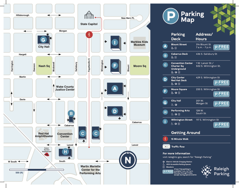
Parking
The closest public parking decks to Red Hat Amphitheater are located at
- Lenoir Street between Salisbury and McDowell Street
- South Street between Salisbury and McDowell Street
- Davie Street between McDowell and Dawson Street
- Cabarrus Street between McDowell and Dawson Street
- Salisbury Street between Cabarrus and Davie Street
Accessible parking spaces are available on the first level of each garage. Visit our Accessibility page for more information.
Please note that the listed parking decks are owned and operated by McLaurin Parking. Red Hat Amphitheater does not control the parking rates for these garages.
Parking Locations
View more information about parking in Downtown Raleigh, as well as view a map of parking decks located downtown.
Downtown Raleigh Map
View and download a map of Downtown Raleigh featuring all of our venues.